Search Results
Displaying: 151 – 175 of 2,513 matches for “maps”
-
151. Tonie Frederika Kaufmann Soep: Maps
-
152. Meyer (Max) Rodriguez Garcia: Maps
German interior. In May 1945, he was liberated at the Ebensee labor camp in Austria. These maps
-
153. Map used as trial evidence
This map of the Treblinka I forced-labor camp was drawn by ... Holocaust survivor Manfred Kort in 1946. In 1990 Kort donated the map to the United States Holocaust
-
154. Kyiv (Kiev) and Babyn Yar (Babi Yar) - maps
-
155. Map of Theresienstadt from an original document
Map of Theresienstadt from an original document (1942-1945) and mounted in an album assembled by
-
156. Twelfth Army Group Situation Map for D-Day
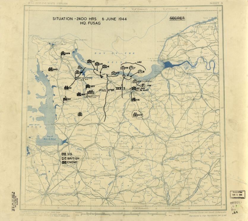
Dated June 6, 1944, this US Twelfth Army Group situation map shows the presumed locations of ... of Normandy. Drafted during the war, the content in this historical map reflects the information that
-
157. Map, Judenvernichtung im Donauraum
also includes three maps of concentration camps and other materials relating to the Holocaust ... Map published by E. Kossoy, Munich, showing the locations of deportation routes in Eastern Europe. ... Maps (lcsh)
-
158. Map of Poland and the Baltics
also includes three maps of concentration camps and other materials relating to the Holocaust ... Map published by E. Kossoy, Munich, showing the locations of death camps in Poland and the Baltics ... Maps (lcsh)
-
159. Zbiór planów i map (Sygn. 245)
Collection of maps and plans ... Zawiercie (Poland)--Maps. ... Sosnowiec (Poland)--Maps.
-
160. Map of Western Germany, in French.
Tourist maps (lcsh) ... Maps
-
161. Map of Munich
a map of Munich. ... Color map of Munich.
-
162. Map of Treblinka drawn by a former inmate
Map of Treblinka I created by Fred Kort, 1946. ... Maps (lcsh)
-
163. Color map of France with commentary
Maps (lcsh) ... Maps
-
164. 1936 Olympics Map of Berlin
The collection consists of a 1936 Olympics map of Berlin and a 1936 route distance schedule for ... Tourist maps (lcsh)
-
165. Lufthansa map of distances 1936
The collection consists of a 1936 Olympics map of Berlin and a 1936 route distance schedule for ... Tourist maps (lcsh)
-
166. Map of Leipzig and surrounding area
Tourist maps (lcsh) ... Maps
-
167. Map, "Germany the Beautiful Travel Country"
Tourist maps (lcsh) ... Maps
-
168. 1942 color street map of Litzmannstadt (Łódź), Poland
Łódź (Poland)--Maps. ... 1942 map of Litzmannstadt (Łódź), Poland with an alphabetical street directory. The city had been
-
169. Map of Jagerndorf
Folding map of Jagerndorf, Czechoslovakia, where Erna Langschur was born. ... Maps (lcsh) ... Maps
-
170. Map promoting German tourism acquired by Max and Irene Bray
Deutschland das schöne Reiseland map ... Large map promoting regional tourism throughout Germany. The map was acquired by Max and Irene Bray ... was being courted for employment in Germany at the time. The map was among other items left for the
-
171. Map of the "small" ghetto in Czestochowa.
CZESTOCHOWA; DOCUMENTS; GHETTO/OCCUPATION; MAPS/PLANS
-
172. 1939 Deutsche Automobilclub map of Germany
Consists of one large folded color map of Germany, entitled "Strassenzustandskarte von Deutschland ... or were controlled by Germany. The map is stamped as having been owned by Major John Hinkel (later ... Chris Hinkel donated this map to the United States Holocaust Memorial Museum on May 10, 2007.
-
173. Map of massacre sites near Naishtot, Lithuania
The map of Naishtot, Lithuania (now known as Kudirkos Naumiestis, Lithuania), made by Ralph ... Goldberg in 1971, lists the names of the Jews of Naishtot who were killed during the Holocaust. This map ... The map was given to the United States Holocaust Memorial Museum anonymously in Aug. 1993.
-
174. Maps of Ukraine, Transnistria, and Rumania
Ukraine--Maps. ... Romania--Maps. ... Contains copies of wartime maps of Ukraine, Transnistria, and Rumania [sic], reproduced from the
-
175. Hitler and others study map
Hitler stand over map on desk. Pointing at maps, discussing. ... MAPS


